Northern Virginia Dayhikes
Shenandoah National Park, North Section
These hikes are listed roughly in order from north to south. The trails
are usually best accessed from the edge of the park (when possible)
so that you can hike
up and then down, rather than the reverse.
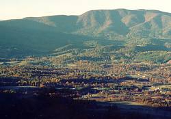
The north section of the park runs from Front Royal to Thornton Gap.
Mile markers on the Skyline Drive start at 0 from the north end.
 Some of the interesting shorter hikes not listed here include the Fox Hollow
Trail, Fort Windham Rocks, Compton Peak, and
the Pass Mountain Overlook Loop. The length of the Skyline Drive through this
section of park is 32 miles (w/ 35mph speed limit) and provides nice views
of the rolling hills to the east and the Shenandoah Valley to the west.
Some of the interesting shorter hikes not listed here include the Fox Hollow
Trail, Fort Windham Rocks, Compton Peak, and
the Pass Mountain Overlook Loop. The length of the Skyline Drive through this
section of park is 32 miles (w/ 35mph speed limit) and provides nice views
of the rolling hills to the east and the Shenandoah Valley to the west.
- On-line References
- Guide
to Shenandoah National Park contains good detailed descriptions of trails and small
area maps.
- The National Park Service
has good information and a large park map in PDF (Adobe Acrobat) format.
- The Potomac
Appalachian Trail Club has more good info and slightly smaller JPG images
of the park map.
- Distance:
- down and back - 1.3/325
- loop - 8.5/2000 (rough estimate)
Location: the loop can be accessed from the west edge of the park
near Browntown. It can also be accessed from the Skyline Drive around mile
10, which is where you would start to just go to the falls and back.
Details: Description of down and back trip from
Guide to SNP.
See
also park references.
Description: The highlight of this trail is an 80 foot series of
cascades at the head of a small ravine, but it usually doesn't have much
water flow and it requires a bit of scrambling to actually see it. Scramble
up the other side and you'll find some nice rocks with views down the ravine.
The loop also takes
you by the interesting Fort Windham Rocks and to the view on Compton
Peak.
Notes:
I haven't hiked the loop, so I can't comment personally on it.
It requires some bit of walking on roads to complete the circuit.
The walk down to the falls is on a fire road, but the forest still provides
good shade.
last hiked: 1999
- Distance:
- loop - 13/2100 (add about 1.2/600 to Big Devils Stairs overlook)
- one way shuttle - 5.5/1300
- up and back to S. Marshall and N. Marshall - 2.4/400
Location: Skyline Drive miles 15-17
Details: Description and maps from
Guide to SNP
(see "Bluff Trail and AT").
See also park references.
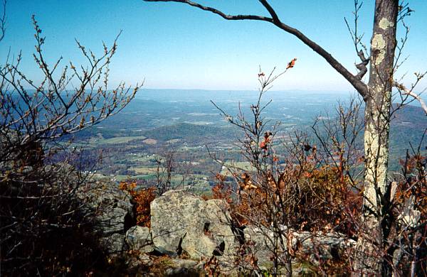
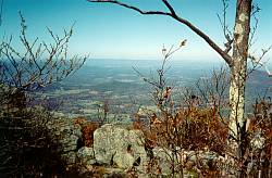
Picture: Looking west from North Marshall
Description: On the west side of the loop, the Appalachian
Trail climbs to nice overlooks on both the south and north peaks of
Mount Marshall. On the east side, the fairly level Bluff Trail goes through
a nice section of forest with some pleasant winter views.
Notes:
A parking lot on the Skyline Drive provides easy access to North Marshall,
so you can expect to see some foot traffic here, but not nearly as bad as the
more popular trails in the park.
last hiked: 1999
Distance: about 5.5/1900
Location: Skyline Drive at Gravel Springs Gap, mile 17.6
Details: Description and maps from
Guide to SNP.
See
also park references.
Description: This circuit takes you down along the rim of Big Devils
Stairs and then climbs back up the center. On the way down, it passes an
excellent overlook of the impressive canyon.
The real fun, however, is bushwhacking back up. There was a trail
here once, but it is long gone now.
When the water is low, you can walk right in the streambed most of the way.
There are only a few sections which actually require crawling up rocks and
I think you can go around these if you really want to. There is a nice
waterfall at the head of the canyon and beyond that are some very large
hemlocks which appear to have been spared from both woolly adelgid and humans.
The hike gets more difficult after that point, since the rest of the
bushwhack goes through forest clogged with fallen trees and greenbrier.
Notes:
- Because of the off-trail section, this is a much more challenging
hike than the distance would suggest. It may also be much more difficult than
what I encountered if you were to go when water levels are higher and you
can't walk in the stream bed.
- I've seen it recommended that you climb out of the gorge at the
upper waterfall and head back towards the trail you came down on. I haven't
done this, but it shouldn't be too difficult and would save a lot of
bushwhacking through difficult terrain.
- Access from the bottom is through private property and is no longer open
to the public.
last hiked: fall, 1999
- Distance:
- short loop - 5.5/1780
- medium loop - 8.2/2200
- long loop - 11.6/2920
- longer loop - 13/3200
Location: accessed from edge of park at Washington, VA. Longer
options can also be accessed from the Skyline Drive around mile 20 to 22.
Details: Description and maps from
Guide to SNP.
See also park references.
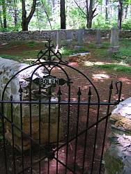
Picture: The Bolen Cemetery
Description: The highlight of this trail is a section of about one
mile through Little Devils Stairs, a steep, narrow canyon filled with
cascades and cliffs.
The trail requires a little bit of rock scrambling through
this section and can be a bit treacherous when wet.
On the longer loops, you climb up to the Skyline
Drive and then follow the Appalachian Trail to several viewpoints. All but
the short loop follows Piney Branch back down the mountain, passing a
small waterfall near the bottom. A short climb from there takes you past the
old Bolen cemetery and then it's back down a fire road to the starting point.
last hiked: 2001
- Distance:

- 9.2/2300 or 9.6/2600
- add if starting from (approx):
- Hogback Overlook - 1.2/240
- Mathews Arm entrance road - 1.6/120
- Elkwallow Wayside - 4.0/100
- Thompson Hollow - 1.5/200
- to the falls and back:
- Hogback Overlook - 6.5/1850
- Mathews Arm Campground - 3.8/1140
Location: Mathews Arm Campground (mile 22). This is closed
in winter, thus the other possible start points listed above. It
can also be accessed from the west edge of the park near Bentonville
(Thompson Hollow access).
Details: Description and maps from
Guide to SNP.
NPS has map of Mathews
Arm area.
Picture: Doe and fawn on the Tuscarora Trail
Description: Although these are the highest falls in the park,
you cannot really see the entire falls at once. The viewpoints are
all partially obstructed and you may have to do a little off-trail
scrambling to
actually see the falls (keeping in mind that some sources claim this
to be a likely place to find rattlesnakes). It's probably best in spring
when the water is high and the trees are still relatively bare. Nevertheless,
it's still a nice sight and the view west from the top of the falls is
quite good. At the bottom of Thompson Hollow, Overall Run has a very
pretty series of pools, and the forest is very nice throughout most of the
loop.
last hiked: spring, 2000
- Distance:
- loop with Neighbor Mountain - 14/2600
- loop with The Knob - 12/2600
Location: Elkwallow Picnic Area (mile 24) or, for Neighbor Mountain,
around mile 26.5. Maps show a trail coming in from the west edge of the
park, but I don't know if there is access from that point.
Details: Description and maps from
Guide to SNP.
See also park references.
Description: The Jeremys Run trail features a long section of
trail through one of the largest valleys coming off of the main ridge within
the park. The trail crosses the stream 14 times; be prepared to get your
feet wet on the lower crossings if the water level is high. Neighbor Mountain
provides some obstructed views; the Knob does not, but it does go through
a nice isolated section of forest.
The mellow beauty of the stream valley and the feeling
of remoteness give this hike a high rating.
Notes:
Most sources I've seen describe the loop
as going down Jeremys Run and then up the other portion of the circuit, but
I think it works much better saving the gentle ascent of Jeremys Run for the
last part of the hike.
last hiked: 2002
Return to Northern Virginia Dayhikes
Questions, comments, suggestions?
Please contact feedback@bobcantor.com.
Visit my Home Page
Copyright 2008 by Robert Cantor
 Some of the interesting shorter hikes not listed here include the Fox Hollow
Trail, Fort Windham Rocks, Compton Peak, and
the Pass Mountain Overlook Loop. The length of the Skyline Drive through this
section of park is 32 miles (w/ 35mph speed limit) and provides nice views
of the rolling hills to the east and the Shenandoah Valley to the west.
Some of the interesting shorter hikes not listed here include the Fox Hollow
Trail, Fort Windham Rocks, Compton Peak, and
the Pass Mountain Overlook Loop. The length of the Skyline Drive through this
section of park is 32 miles (w/ 35mph speed limit) and provides nice views
of the rolling hills to the east and the Shenandoah Valley to the west.