Northern Virginia Dayhikes
Shenandoah National Park, Central Section
|
These hikes are listed roughly in order from north to south. The trails
are usually best accessed from the edge of the park (when possible) so that
you can hike
up and then down, rather than the reverse.
The central section
of the park runs from Thornton Gap (mile 31.5) to Swift Run Gap (mile 65.5).
The highest peaks in the park can be found along the Skyline Drive in
this section, which probably also has the greatest concentration of
impressive views and interesting trails.
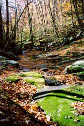
Some of the better short hikes include Marys Rock, Stony Man,
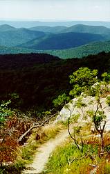
Millers Head (see picture of trail),
the Limberlost Trail, Hawksbill summit, Dark Hollow Falls,
Lewis Spring Falls, and Bearfence summit.
|
|
The southern section of the park also has excellent views and trails, many with
a more mountainous and remote feeling than the ones further north, but this
gets beyond my 2-hour drive limit from the DC area.
- On-line References
- Guide
to Shenandoah National Park contains good detailed descriptions of trails and small
area maps.
- The National Park Service
has good information and a large park map in PDF (Adobe Acrobat) format.
- The Potomac
Appalachian Trail Club has more good info and slightly smaller JPG images
of the park map.
- Distance:
- Buck Hollow/Buck Ridge circuit - 6.5/1800
- side trip to Marys Rock - 2.9/830
- side trip to Hazel Falls - 4.6/800
Location: Near Sperryville, just inside the park on the road
up Thornton Gap, or from the Skyline Drive at the Meadow Spring Parking
area (mile 33.5).
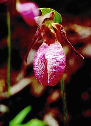
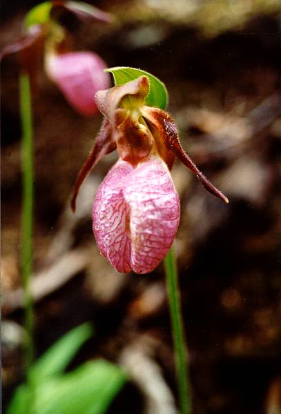
Picture: Pink Lady's-Slipper orchid on the Buck Hollow Trail.
Details: Description and maps from
Guide to SNP. See
also park references.
Description: A pleasant hike by a small stream, Buck Hollow is
a very scenic area and you will usually have
it all to yourself. The hike down Buck Ridge provides a few limited views and
also takes you through some interesting burned out areas. Most of it is
recovering quickly, but one short section was pretty well devastated. Side
trips take you to the excellent (but often crowded) Marys Rock overlook or
to a small waterfall and cave on the Hazel River.
Notes:
- The lower portion of Buck Ridge is very steep.
Many people prefer going up this and down the hollow in order to avoid the
pounding of going down such a steep trail, but I personally think it's more
scenic to be looking up the hollow while you hike so I save the steep section
for last.
last hiked: May, 2001
- Distance (estimated):
- Limberlost/Skyland/Loop circuit - 10/2800
- Loop from Limberlost - 9/2500
- Loop from Old Rag parking - 5.1/2200 (+1.6/200 from lower pkg)
- Limberlost to Robertson peak and back - 5.2/1200
- Loop = Robertson Mountain/Corbin Hollow loop
Location: From the Skyline Drive at the Limberlost Trail
(mile 43), White Oak Canyon (mile 42.6) or Stony Man Nature Trail (mile 41.7)
parking areas.
See Old Rag for hiking up to the loop.
Details: See "Old Rag" for partial map at
Guide to SNP. See
also park references.
Description: The centerpiece of this hike is a loop made up by the
Corbin Hollow and Robertson Mountain trails. The first takes you through
a nice hollow with 2 pretty stream crossings near the bottom. The second
gives you a few good looks at Old Rag and takes you up to a very
good view from the top of Robertson Mountain. It's not as impressive a
view as from Old Rag,
but you probably won't have to share it with anyone else.
As an added attraction, the Limberlost Trail takes you through a
very nice hemlock forest.
Notes:
- The Robertson Mountain trail is very steep. From the bottom of Corbin
Hollow, it climbs about 1700 feet in only 1.6 miles.
- At Stony Man Nature Trail parking, an easy 1.6 mile/340 foot hike or
a 3.5/770 circuit will take you to an excellent view at the top of Stony Man.
The circuit described above also takes you by the trail to Millers Head
(1.6/450).
- Those looking for a challenge could combine the loop with the Old
Rag circuit for a hike with a boulder scramble, almost 12 miles of trail, and
nearly 4000 feet of climbing.
last hiked: 2002
Distance:
- Ridge Trail loop - 7.1/2200
- from lower pkg area, add about 1.6/200
- up and back from Berry Hollow - 5.4/1760
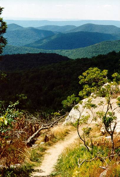
Location: East edge of park at Nethers, VA (or at Berry Hollow). For
a longer trip, it can also be accessed from the Skyline Drive around miles
42-43.
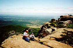
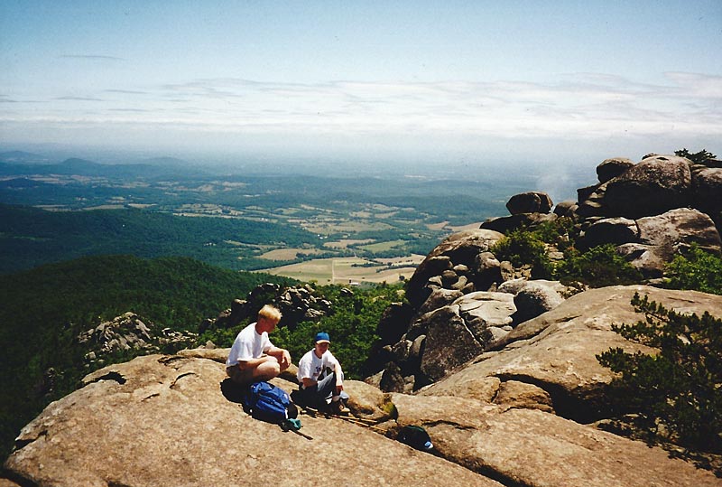
Picture: Resting just below the
summit.
Details: Description and maps from
Guide to SNP. See
also park references.
Description: Standing by itself just east of the main Blue Ridge,
Old Rag provides wonderful views of the mountains in the central portion of
the park and the rolling farmland to the east. Along the rocky ridge of the
mountain, the trail features its well known boulder scramble as it winds
over, under, and around large boulders. It squeezes through rock slits,
climbs up a narrow natural staircase and through a short tunnel before reaching
the summit. It's even nicer around early June when the mountain
laurel is in bloom, but after the fires in 2000 it may be a few years
before that happens again.
Notes:
- Because of the boulder scramble, the trail is more difficult than the
distance would suggest. Add at least an hour unless you're particularly
comfortable scrambling up and down rocks. No special climbing skills
are required, but
if you have any doubts about your abilities, you may not want to try this
alone. Long pants are recommended and thin gloves might also be helpful.
- This is a very popular trail. I have heard people
complain about having to wait in line at some of the bottlenecks on the
boulder scramble on crowded weekends. Try to get there as early as possible
or go in the middle of the week.
last hiked: October, 2005
- Distance:
- short loop - 7.7/2270
- standard loop - 9.1/2560
- extended loop - 12/3100
- up to upper falls and back - 5.3/1670
- down to upper falls and back - 4.6/1040
Location: East edge of park near Banco. May also be accessed from
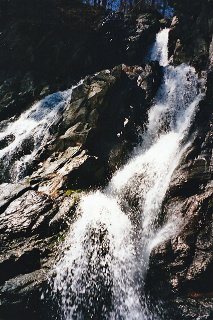
Skyline Drive between miles 42.5 to 45.5.
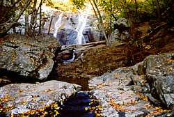
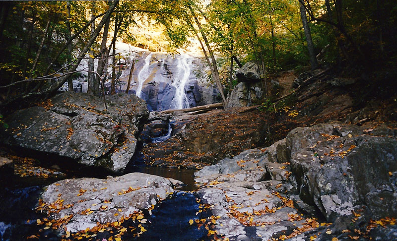
Picture: The
lower falls in White Oak Canyon (falls #6)
Details: Description and maps from
Guide to SNP. See
also park references.
Description (standard loop):The hike up White Oak Canyon takes
you through a beautiful ravine passing 6 waterfalls along the way and
providing a very nice view back out to the east. After climbing
out of the ravine, you walk through a shady hemlock forest and then
connect up with the Skyline Drive at Crescent Rock for an excellent view
to the west. Hiking back down Cedar Run, you'll pass a natural waterslide
and another waterfall before returning to your starting point. The
extended loop adds a trip to the excellent view at Hawksbill summit, the
highest point in the park.
Notes:
- A very popular trail, this can get very crowded on weekends, especially
the upper section.
- The Cedar Run section of trail is very steep.
last hiked: September, 2003
- Distance:
- short loop - 8.7/1700
- medium loop - 10.3/1950
- long loop - 11.6/2500 (rough estimate)
- longer loop - 12.8/2600 (rough estimate)
Location: The east edge of the park at Syria. This can also be
accessed from the Big Meadows area on the Skyline Drive (mile 51).
Details: Description and maps of upper section from
Guide to SNP
under "Rose River Falls".
NPS has detailed maps of
Big Meadows area.
Description: The main attraction is bushwhacking up the scenic
Rose River with its many small falls, cascades, and pools and a wonderful
feeling of isolation to go with it. The remaining features overlap the
Rose River Loop described below. The short loop takes you along Hogcamp
Branch and the base of Dark Hollow Falls. The medium loop goes to Rose
River Falls and Fisher Gap. The long loop allows you to come down Dark Hollow,
passing the falls, and the longer loop adds the Blackrock overlook. All of
them use a fire road to reach the edge of the park at the bottom of the Rose
River.
Notes: Give yourself extra time for the 2 mile off-trail stretch.
With water levels low, you can walk mostly along the streambed, but it's
more difficult with high water. This
area has some large sections of stinging nettles and bushwhacking always puts you at a higher
risk for picking up ticks; long pants are strongly recommended no
matter how hot it is.
last hiked: 2002
- Distance:
- short loop - 3.7/860
- medium loop - 6.5/1600
- long loop - 9/2320
- Dark Hollow Falls and back - 1.4/440
- Rose River Falls and back - 2.7/720
- many other variations can be created
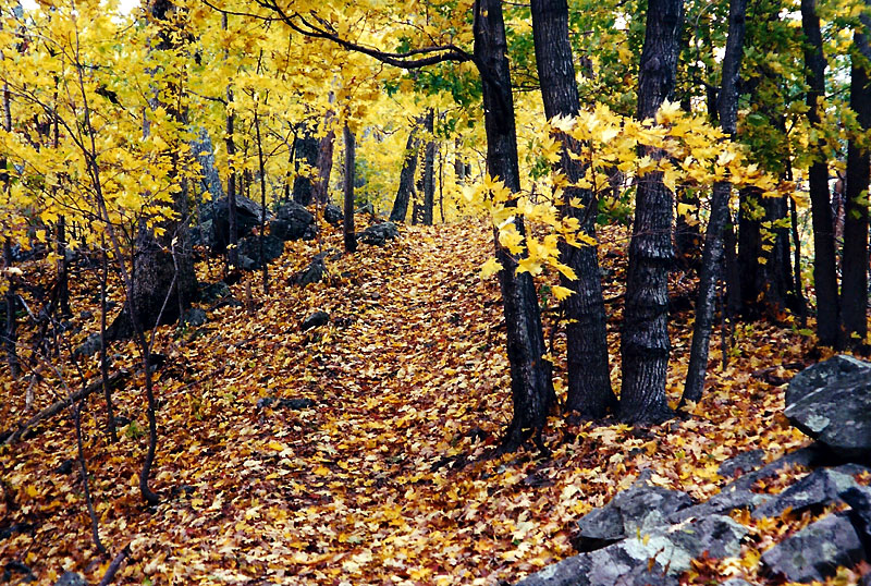
Location: Big Meadows area on the Skyline Drive (mile 51)
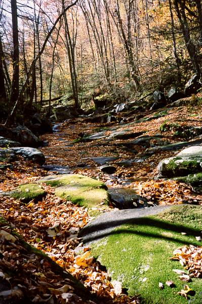
Picture: Hogcamp Branch filled with leaves
Details: Description and maps from
Guide to SNP.
NPS has detailed maps of
Big Meadows area.
Description (medium loop): Starting from the picnic area behind
the campground, you follow the Appalachian Trail to a viewpoint at Fishers
Gap, then begin descending to Rose River Falls. This is a nice 2 part
falls, but not much to look at when the water is low. The trail continues
down the river, passes the site of an old copper mine, then turns up
Hogcamp Branch for what may well be the prettiest section of stream
anywhere in the park. From there you climb up Dark Hollow, passing the
falls, then take a nature trail to a good view at the Blackrock overlook.
For the long loop, add a trip to the very scenic Lewis Spring Falls (see
below).
Notes: This is not a trail for someone looking to get away from
civilization.
It crosses the Skyline Drive twice, both times at parking lots, goes
through a developed area to get to the Blackrock overlook, and skirts the
edge of a campground. As if that weren't enough, the Dark Hollow section
of the loop is one of the most heavily used trails in the park.
last hiked: 1999
- Distance:
- down and back - 2/900 (estimate)
- circuit - 3.7/1200
- many other variations can be created
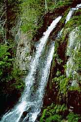
Location: Big Meadows area on the Skyline Drive (mile 51)
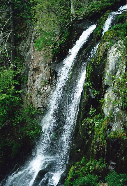
Picture: Lewis Falls
seen from the viewing platform. See also the
view from the base.
Details: Description and maps from
Guide to SNP.
NPS has detailed maps of
Big Meadows area.
Description: When the water is high, Lewis Falls is one of the
prettiest falls in
the park. There is an excellent viewing platform at the top and an unmaintained
trail to an impressive view from the bottom. The circuit also contains a
few nice views to the west.
Notes: Combine this with the Rose River Loop described above to create
any number of dayhike circuits ranging from moderate to strenuous.
last hiked: September, 2003
- Distance:
- Mill Prong down and back - 4.1/870
- Mill Prong loop - 6.8/1000
- Laurel Prong/Mill Prong - 7.4/1520
- Laurel Prong/Mill Prong/Rapidan Road - 10.2/1800 (estimate)
- Rapidan Road/Mill Prong - 9.9/1165
- Rapidan Road/Laurel Prong - 13.3/1800 (estimate)
Location: Big Meadows Wayside (mile 51) or Milam Gap (mile 53)
Details: Description and maps from
Guide to SNP.
NPS has detailed maps of
Big Meadows area.
Description: The highlight of this trail is exploring historic
Rapidan Camp, a retreat created for and used by Herbert Hoover. There
are many historical signs and some of the buildings are still maintained.
There is also a small waterfall near the camp on the Mill Prong trail.
Notes:
- This is also known as Hoover Camp in many references.
- The Rapidan Road section is not particularly interesting and
can get very hot in the summer. I would recommend using one of the first
four routes listed.
last hiked: 1999
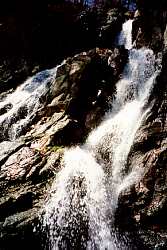
- Distance:
- to overlook and back - 2.6/850
- to base of falls and back - 4.2/1050
- short loop - 4.7/1315
- Pocosin Trail loop - 9.8/2000
Location: South River Overlook (mile 62.7). Pocosin Loop can also
be started at mile 59.5. Both a trail and a road extend to the east edge
of the park, but I don't know if there is access from those points.
Picture: Looking up from the base of the falls.
Details: Description and maps from
Guide to SNP.
See also park references.
Description: South River Falls is probably the single most impressive
waterfall in the park. It sits at one edge of a huge natural amphitheater with
the trail taking you to an overlook at the other edge. You can
also hike to a pool at the base of the falls.
Notes: The falls are a very popular spot and can get quite crowded,
but the rest of the Pocosin Trail loop does not get much use.
last hiked: 1998
Return to Northern Virginia Dayhikes
Questions, comments, suggestions?
Please contact feedback@bobcantor.com.
Visit my Home Page
Copyright 2008 by Robert Cantor