Northern Virginia Dayhikes
No more than one hour away
- Distance:
- loop - 4.6/1300
- to overlook and back - 2.4/900
- from town, add 1.4 (no climbing)
Location: Harpers Ferry, WV (where Maryland, Virginia, and West Virginia
meet)
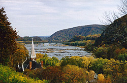
Picture: View from
Jefferson Rock, accessed via short trail from
town.
Description: The trail takes you up a hill where you'll find the
remains of fortifications and encampments made by the Union army during the
Civil War. A number of signs along the way describe what you are seeing.
Limited views can be had from the top. Overlook Cliff provides an
excellent viewpoint of Harpers Ferry, the Potomac River, and
the Shenandoah River.
Notes:
- I like starting this hike from the town of Harpers Ferry. You cross a
bridge and walk up along the C&O Canal to pick up the trailhead. When you
get back, you can enjoy the town with its shops, restaurants, and ice cream
parlors in addition to the many interesting historic sites. Although I did
not rate this particularly high as a dayhike, it does get very high ratings
as a fun place to spend the day.
- Overlook Cliff can get very crowded.
- Take some time to walk the Virginius Island trail, a 3/4 mile loop
with interpretive markers which takes you past the remains of 19th century
industry. It starts at the Shuttle Bus stop and quickly
gets you away from much of the crowds.
- The Appalachian Trail runs right through Harpers Ferry. Take it north to
follow the C&O Canal for several miles and then climb to an excellent
overlook at Weverton Cliffs. Go south past Jefferson Rock to cross the
Shenandoah River and climb to some views at Loudon Heights. Or stop at the
river and come back via the Virginius Island trail and then you can say that
you've hiked the entire length of the AT in West Virginia.
last hiked: 2005
- Distance:
- short loop - 8.7/1200
- long loop - 10/1760 (includes Cat Rock)
Location: About 15 miles north of Frederick, MD, access from US 15.
Description: Walk over to Cunningham Falls, then hike up to some
pleasant views and interesting rock outcroppings. The longer loop will
also take you by a lake.
Notes:
- There are many trails in this area, and many possibilities for shorter
loops than the ones listed above.
- Do not expect to get any feeling of remoteness here. The falls
and lake are right next to parking lots, and the longer loop will have you
crossing paved roads in 4 places.
last hiked: 2000
- Distance:
- circuit - 8.1/1700
- summit from upper parking - 0.5/350
Location: Access from I-270 about 10 miles southeast of Frederick, MD
(can also be reached via Point of Rocks or Whites Ferry).
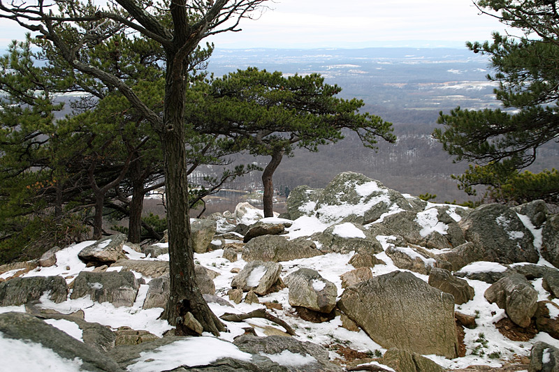
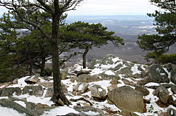
Picture: Winter view from the near the summit.
Description: Sugarloaf Mountain, standing pretty much by itself,
provides excellent views of the rolling farmland surrounding it. The quartzite
outcroppings at and around the summit are very interesting and the trail
which climbs through them (starting from the upper parking area)
is a particularly scenic one. The other trails
provide a few views, but are mostly just a nice hike through the woods.
Notes:
- The summit gets very crowded.
- Maps showing all the trails are available at the parking areas.
last hiked: 2003 (limited hiking in 2012, 2013)
|
Prince William Forest Park
|
- Distance:
- Pyrite Mine loop: 6.1
- Beaver loop: 7.5
- combined loop: 12.0
- full area loop: 15.6
Location: Access from I-95 at Quantico, about 20 miles south
of Springfield, VA
Map: Map and other information from the
National Park Service
Description: A pleasant walk through mature forest and along
some nice streams. Passes 2 very small waterfalls and the
remains of an old Pyrite mine (which I've never actually seen since that
part of the
trail has been closed for reclamation for the last several years).
Notes:
- The elevation changes are negligible, but there are a
few short steep hills and long gradual grades.
- This park is run by the National Park Service and there is an
excellent map of all trails in their brochure, which you can pick up
at the entrance station or the visitor center.
last hiked: Spring, 2003
|
G. Richard Thompson Wildlife Management Area
|
- Distance (estimated):
- lake loop - 7.2/1300 (includes wildflower loop)
- wildflower loop - 2/300
Location: Just north of I-66 at Linden or Markham, VA (just east of Front
Royal)
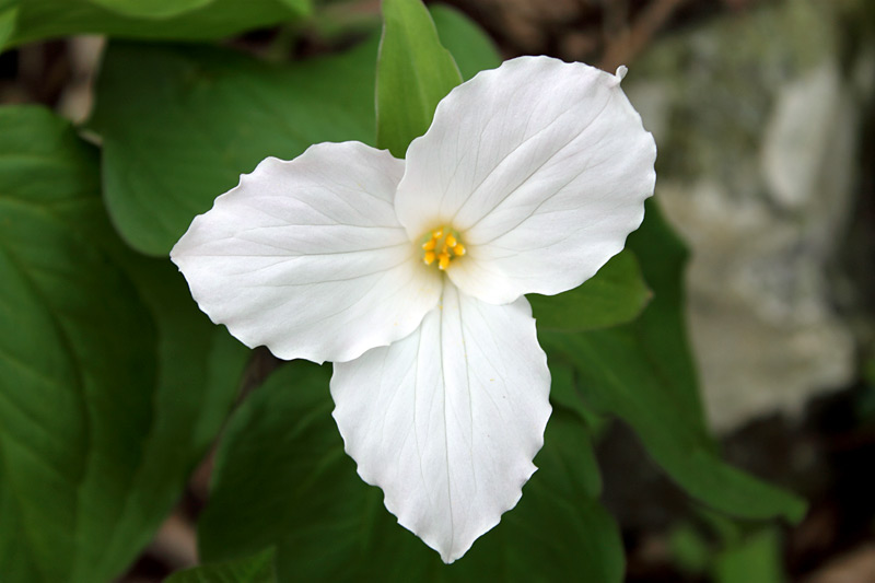
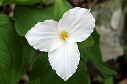
Picture: Large-flowered Trillium
Map: Good on-line
map
and other information.
Description: Most of the year, this is a rather ordinary walk on
the Appalachian Trail along a rocky, forested ridge. In early May,
however, the forest comes alive with what may be the largest collection
of Large-flowered Trillium anywhere in North America.
Notes:
- The wildflower loop, maintained by the Virginia Native Plant Society,
gets very crowded when the Trillium are in bloom.
- For quick access to the wildflowers, enter the western side of the area
and stop at the parking lot just after the road becomes gravel. The linked map
above can be deceptive - the lot marked 5 on the map has a sign designating
it as lot 6, and you'll pass some small unmarked radio towers just before
you reach it, with the larger towers shown on the map just beyond.
last hiked: May, 2001
- Distance (elevation change estimated):
- Morning Choice/Ridge Trail loop - 5.1/400
- Rockburn Branch loop - add 1.2/120 to MC/RT loop
- Cascade Falls Loop trail - 1.8/300
- To the falls and back - 0.4/100
Location: Patapsco Valley State Park,
Avalon area - just off I-95 a few miles south of Baltimore
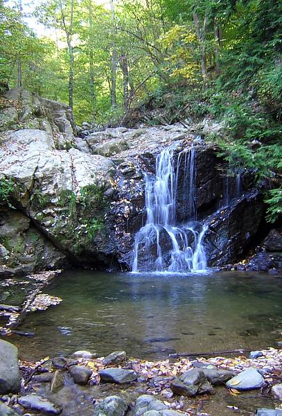
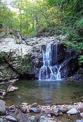
Picture: Cascade Falls
Map: Detailed map may be
purchased on-line for a small fee.
Description: Cascade Falls is a small but very pretty little spot
on a side creek of the Patapsco River. The trail follows the scenic creek
for a short distance and then continues through the forest, occasionally
passing some large, open fields.
Notes:
- These trails are heavily used by mountain bikers. Expect to share the
trail.
- Also at the trailhead is the swinging bridge, a pedestrian bridge which
crosses the Patapsco River.
- Patapsco Valley State Park is a very large park containing over
170 miles of trails. I've only had the chance to explore a very small
portion of it.
last hiked: Spring, 2006
Return to Northern Virginia Dayhikes
Questions, comments, suggestions?
Please contact feedback@bobcantor.com.
Visit my Home Page
Copyright 2008 by Robert Cantor