Northern Virginia Dayhikes
Inside or near the Beltway
- Distance:
- main loop: 4 miles, a lot of short ups and downs
- main loop using forest trails: 6.8/500
- B loop: est 2.4 miles
- main loop to B loop: 0.6 one way
- C loop: est 2.7 miles
- B loop to C loop: 0.4 one way
Location: Great Falls Park, Maryland. May also be accessed from
parking lot across the street from the Old Anglers Inn. The C loop
is accessed at Carderock.
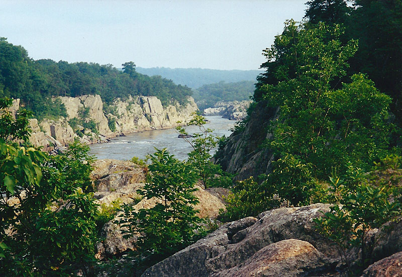
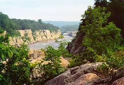
Picture: Looking up river at the
Mather Gorge. See
also my other Great Falls
photos.
Map: Maps and more information from the National Park Service.
Description: The main loop follows the edge of Bear
Island along the top of the cliffs of Mather Gorge, providing many
excellent views of the Potomac River and many scenic spots among the rocks.
The return half takes you back on the towpath along the historic C&O Canal
(by crossing the C&O canal, you can extend the loop using some forest trails).
You can also head downstream to the very pleasant (and less crowded) B section
of the trail and continue even further to hike through the Carderock area on
the C section.
Notes:
- Much of the A loop goes over boulders and there's one short traverse across a steep rock face. Give yourself more time than the short distance would
suggest.
- This trail is very crowded on weekends. The C&O
Canal towpath section of trail gets heavy use even on weekdays.
- A very short side trip from the start of the hike at Great Falls Park will
take you on a boardwalk through a rare example of bedrock river terrace
forest, ending in an excellent viewpoint of the falls.
- You can get a map at the park entrance station, but it isn't really
necessary unless you're going to use the forest trails.
There is a small fee to enter the park, but you may avoid this by
starting the hike from Carderock or from the parking area at the Old Angler's
Inn.
- Your hike may be extended up or down river by walking on the C&O Canal
towpath (you could actually take this all the way into Georgetown or all the
way out to Harpers Ferry and beyond).
last hiked: Spring, 2019
- Distance:
- 10 miles one way, up to 0.5 miles to access trail

- Location: Trail runs along the Virginia side of the Potomac River,
starting at the Beltway and extending south to Rosslyn at Key Bridge.
Recommended access points (N to S):
- Turkey Run Park - several nice trails down to the river
- Parking lot at Chain Bridge - easy access to Pimmit Run and overlook
- Zachary Taylor or Potomac Overlook Park - scenic hike down Donaldson Run
- Windy Run park - nice access to southern end of trail
Picture: Sessile Trillium (Toadshade)
on the trail in mid-April.
Map: An on-line brochure has a very good
map of the trail
(although a map isn't really necessary for hiking this).
Description:
Although right next to DC, you won't see many people on this trail during
a weekday.
It mostly follows the edge of the Potomac River,
bordered by rocky bluffs and passing several large streams along the way.
The northern portion, accessed via Turkey Run
Park, is probably the most scenic and the most isolated from the urban
noises around you. At Chain Bridge there is a short but pretty section of
trail which runs along Pimmit Creek and also a good overlook from a high bluff.
A loop hike can be made on the southern portion of the trail by crossing Key Bridge
into Georgetown and then following the C&O Canal up to Chain Bridge.
Notes:
- The Turkey Run section of trail is particularly nice in mid to early
April when the flood plains are carpeted with Virginia Bluebells and the
hillsides covered with Spring Beauties and Dutchmans Breeches.
- Portions of the trail may be flooded during times of high water.
You can always find a way around, but you might get muddy.
- A nearly 2 mile section of trail has
to leave the river to go around private property between Turkey Run and Chain
Bridge. This is not a particularly interesting section.
- In Rossyln, the trail ends at the pedestrian bridge to Roosevelt Island,
which has a nice 1.5 mile loop around the island. This is also the northern
starting point of the Mount Vernon trail, a paved trail (used heavily by
bikers and joggers) which will take you past National
Airport, Old Town Alexandria, through some wetlands, and finally to Mount
Vernon (18 miles one way).
last hiked: 2013
|
Manassas Battlefield Park
|
- Distance:
- First Manassas loop: 5.4 miles
- Second Manassas loop: 6.2 miles
- Combined loop: approx 9.6 miles
- various other trails available to extend either loop
- all trails are mostly flat
Location: Manassas, VA
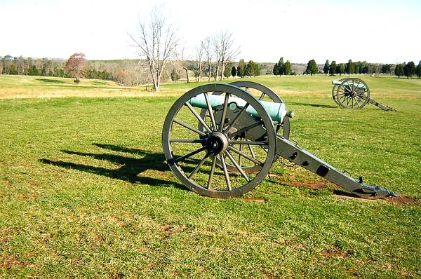
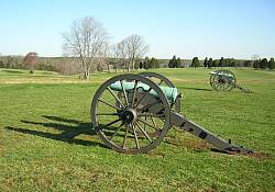
Picture: a battlefield just outside of the Visitor Center.
Map: Map
and description of area.
Description: These walks take you through open fields and forest,
over streams, and past many historical markers and artifacts as it also
takes you back in time to re-live the Civil War battles of First and
Second Manassas.
The First Manassas Trail is probably the more scenic
of the loops as it takes you through a swamp to the Stone Bridge over
Bull Run.
Notes:
- Get oriented at the excellent visitor center. The park brochure has
a small trail map. You'll need it, because the trail signs can be
confusing at times (you can't really get lost anywhere but it's
good to know when you're supposed to be turning).
- Both trails cross a busy highway. Use extreme caution.
- You are supposed to get an entrance permit ($3) if you're going to be
hiking any of the trails.
last hiked: 2004
|
Great Falls/Difficult Run
|
Distance: 5 - 7 miles, one hill of about 100 feet
Location: Great Falls Park, VA
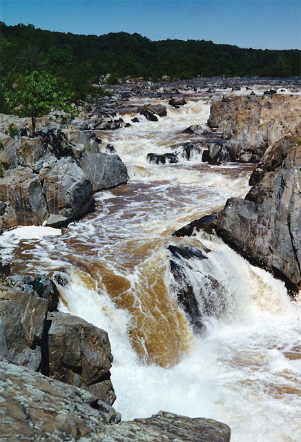
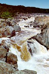
Picture: The Virginia side of
Great Falls, from an overlook
near visitor center. See
also my other Great Falls
photos.
Map: Maps and other information from the
National Park Service
Description: The trail goes
through forest, a small swamp and follows the rocky Difficult Run down
to the Potomac River. It runs along the top of the cliffs lining Mather Gorge,
passes through the 18th century remains of Matildaville and the Patowmack
Canal, and provides access to the viewpoints of Great Falls.
Notes:
- Many trails crisscrossing this area give you a variety of options,
particularly in the areas near the visitor center. A trail leading
upstream from the visitor center will connect you with Riverbend Park
and several more miles of trail.
- You can get a trail map at the park entrance station. There is a small
fee to enter the park, but you can avoid this by using the parking area
at Difficult Run.
- The spectacular scenery here really deserves a higher ranking than what
I gave it, but somehow I just feel that the area is more conducive to short
outings and family picnics than it is to dayhiking. Most of the best views
and interesting historical sites can be easily reached in
5-15 minutes of walking from the visitor center.
last hiked: 2007
Distance: up to 17.7 miles one way with a few moderate hills
- Location: Runs along southwestern border of Fairfax County,
Access (N to S) at:
- Bull Run Regional Park
- Hemlock Overlook Regional Park
- Bull Run Marina
- Fountainhead Regional Park
Map: On-line
Map available (but not needed for
hiking the trail).
Description: Walk through forests along the banks of Bull Run and
the Occoquan River. The south end meanders over hillsides for several
miles before actually starting to follow the river. The north end starts off
in forested flood plains. In between is an excellent trail running mostly
right along the stream. A 0.4 mile trail from Hemlock Overlook Regional Park is
a good access point as it takes you through the forest down to a
rocky section of stream.
Notes:
- In early to mid April, the flood plains at Bull Run Regional Park are
carpeted with spring beauties and Virginia bluebells.
During a good year, it's one of the most
impressive display of wildflowers you'll ever see.
- The trail can get very wet and muddy if it has been raining, particularly
the northern section.
- Hemlock Overlook Regional Park provides the opportunity to make several
partial or full loops of up to 3.5 miles.
last hiked: 2005
|
Fairfax Cross-County Trail
|
Distance: up to 38 miles one way with some hills but little significant elevation change

- Location: Runs mostly north/south through the center of Fairfax County.
Some of the better access points include (N to S):
- Georgetown Pike
- Vale Road
- Miller Heights Road
- Eakin Park
- Wakefield Park
- Lake Accotink Park
- Occoquan Regional Park
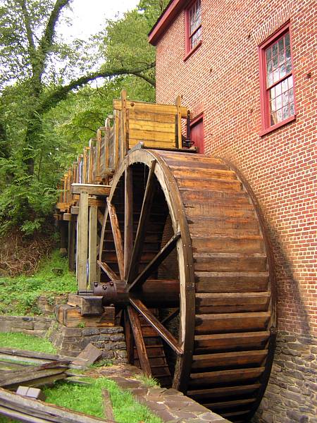
Picture:
Colvin Run Mill
Map: a map is not needed while hiking, but
familiarity with it is highly recommended
since not all areas are well marked and some intersections are confusing.
High-res maps are available from
Fairfax County.
This trail is constantly being added to and improved, so be prepared for
surprises.
Description: A convenient destination when you need to escape
into the forest.
Walk along Difficult Run and Accotink Creek, finding occasional solitude
(on weekdays) and some pretty good bird watching. Deer are common if you're
on the trail early and you might also see an occasional fox.
Notes:
- Through Oakton and past Fairfax City, the trail follows a very
busy road for several miles (from the Oak Marr Rec Center to Thaiss Park).
An unofficial route, which attempts to follow Accotink Creek as long as
possible, requires navigating an unmarked and sometimes overgrown network
of trails. Neither of these are recommended if you can avoid it.
- Through Wakefield Park and from Lake Accotink to Old Keene Mill Road,
you can easily leave the main route and use informal trails which run along
the banks of Accotink Creek. The Cross-County trail also forms half of a
nice loop trail around Lake Accotink.
- Walking from Byron Avenue Park (Old Keene Mill Road) to Hooes Road requires
quite a bit of street travel. The remaining parts of this stretch are
pleasant enough but not particularly notable.
- The start of the trail at Difficult Run can be made part of a loop
using the trails in Great Falls Park
- At Pohick Road, the trail continues south by connecting up with
the Laurel Hills Greenway and then winding its way on an
interesting and unusual trip through the
now vacant Lorton Correction Complex. It finally ends by the river at
Occoquan Regional Park.
- At Leesburg Pike,
Colvin Run Mill
is just a few steps away and well worth the side trip.
last hiked: 2007
- Distance:
- Capital Crescent Trail - up to 13 miles one way
- Capital Crescent/Rock Creek loop - 17 miles
- Rock Creek Park loop - up to 9 miles
- C&O Canal Tow Path - up to 185 miles one way
- Soapstone Valley/Melvin Hazen Loop - 2.5 miles
Location: The Capital Crescent Trail starts in Georgetown, passes
through Bethesda, and ends up in Silver Spring. The C&O Canal Tow Path starts
in the same place and follows the Potomac River west. The
Rock Creek Park loop starts just north of the National Zoo and extends north
to the Maryland border.
- Map:
- Small trail maps with descriptions,
- NPS map of Rock Creek Park
- a low-res map of the
Capital
Crescent Trail
- much information about the
C&O Canal Tow Path.
Description: Rock Creek Park with its extensive forest and many streams
provides an excellent place to escape from the surrounding urban environment.
The Capital Crescent Trail follows an old railroad line along the C&O Canal,
through an interesting tunnel, by Little Falls Branch, and then into
Bethesda and Silver Spring. The C&O Canal Tow Path, situated between the Canal
and Potomac river, starts in Georgetown and heads up the Potomac.
Various other trails in DC will take you through nicely forested stream
valleys.
Notes:
- Metro access to the Capital Crescent trail is from Rosslyn or Foggy Bottom
at one end, Bethesda in the middle and Silver Spring at the other end. Silver
Spring is also only a moderate walk from the northern end of Rock Creek Park.
The central section of the park is best accessed from Cleveland Park (using
the Melvin Hazen Trail), or Van Ness/UDC (through Soapstone Valley).
The Tenleytown
stop provides convenient
access to one end of the Glover Archibold trail, which connects with the
C&O Canal Tow Path at the other end.
- Most of these trails are flat and easy; many are paved. Some of the
smaller side trails and portions of the Ridge Trail through Rock Creek Park
are a little bit rougher. No problem for a hiker but possibly an issue for
somebody expecting an easy urban walk.
- A tunnel on the Capital Crescent Trail lets you bypass most of Bethesda,
but you may want to explore this pleasant area with its many restaurants.
The food court by the Metro station has public bathrooms. There are also
public bathrooms along the trail a few miles from Georgetown at Fletcher's
Boathouse.
- The Rock Creek Park Trail as it passes through Georgetown is narrow,
crowded with bikes and joggers, and right up against a very busy road.
If you're going this direction, I'd recommend a pleasant walk
through Georgetown instead.
- The Rock Creek Trail continues in Maryland and will take you through
Rockville to Lake Needwood. Interesting sights on the way include the Mormon
Temple, Woodend Nature Sanctuary, and the National Park Seminary.
|
Washington, DC - Walking Tours
|
Distance: you decide, flat at the mall but hilly in places

Location: Washington, DC
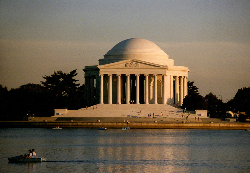
Picture: the Jefferson Memorial. See also
my other Washington, DC
photographs.
Description: Although it isn't really dayhiking, Washington is an
excellent city for walking.
I can't begin to list all of the possible monuments, museums, galleries,
buildings, gardens, and historical sites you could visit. In addition to
the standard sights on and around the Mall, you might consider including
in your walking tour
the National Zoo, Washington National Cathedral,
National Building Museum,
Arlington Cemetery,
Georgetown, Union Station, Dumbarton Oaks Gardens,
East Potomac Park, Embassy Row, Capitol Hill, or any of the city's other
interesting neighborhoods.
Notes:
- The Metro makes it very easy to create very flexible one-way walks. I
particularly like entering the city by crossing either Key Bridge (Rosslyn)
or Memorial Bridge (Arlington Cemetery).
- Although probably a little too remote to be part of your walking tour,
the National Arboretum could be a short day of walking in itself. Check it
out in spring when the azaleas are in bloom.
Return to Northern Virginia Dayhikes
Questions, comments, suggestions?
Please contact feedback@bobcantor.com.
Visit my Home Page
Copyright by Robert Cantor